Employees of the ELKH ATK Institute of Soil Science (TAKI) recently published their own contribution to the preparation of a global map of soils affected by salinisation in the journal Remote Sensing.
The Food and Agriculture Organization (FAO) of the United Nations and its Global Soil Partnership (GSP) have recently initiated the compilation of a global map with a square kilometer resolution of soils affected by salinisation. The aim of the international initiative is to update global and national spatial information on saline soils and to lay the foundations for and support future monitoring of soils of particular significance.
Hungary can look back on a long history and tradition in the field of research on saline land and saline soils. Perhaps one of the most important results of this, which is also highly regarded internationally, is the global map of saline soils, edited by István Szabolcs in 1979, which still serves as a standard for understanding the global distribution of salt-affected soils. The initiative is aimed at updating this global map and placing it on a digital platform, and has also involved staff from the ELKH ATK Institute of Soil Science (TAKI).
TAKI researchers used state-of-the-art machine learning algorithms and multivariate geostatistical methods, as well as multispectral satellite imagery from global earth observations and archival soil maps, to model and map the collective spatial variability of the topsoil (0-30 cm) and subsoil (30–100 cm) of the saline indicators in Hungary in far greater detail than ever before.
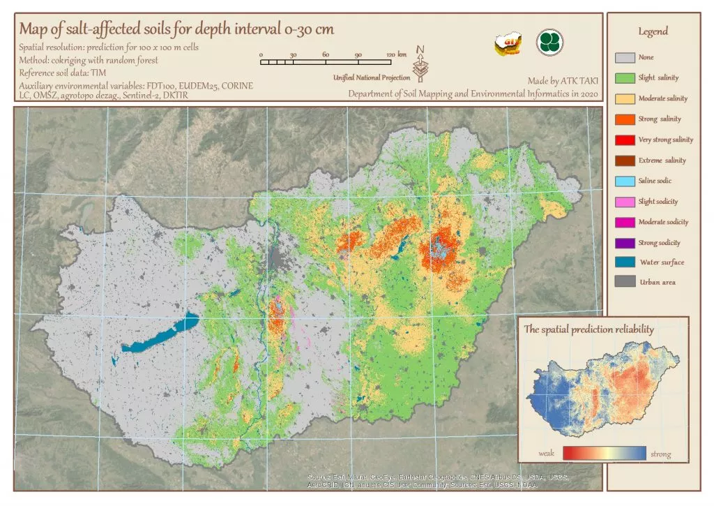
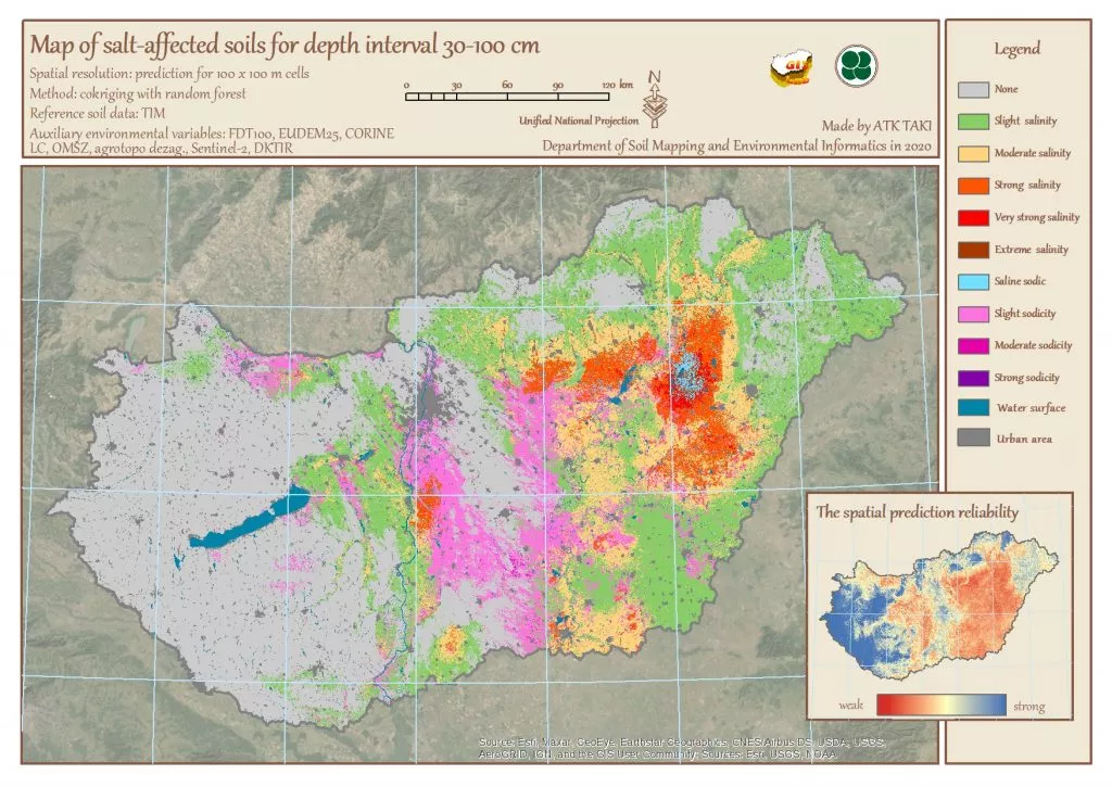
Through their research, the researchers have not only successfully contributed to the creation of a global map of saline soils and added new elements to the already extremely rich and colorful Hungarian saline map series, but also reformed the mapping methodology of these soils. One example for the latter is the modeling and evaluation of spatial uncertainty based on probability theory, which can be used to obtain explicit information about the reliability of the maps. In addition to the application of machine learning algorithms, we can also include the technical interpretation of the resulting complex models with post-hoc techniques, which will unquestionably provide an excellent basis for further saline research.
Although the GSP and FAO have not yet published the compiled saline global map, a series of domestic saline maps prepared by TAKI researchers and a detailed methodological description of its completion are already available after being published in the journal Remote Sensing (D1, IF = 4,509):
Szatmári G., Bakacsi Zs., Laborczi A., Petrik O., Pataki R., Tóth T., Pásztor L., 2020: Elaborating Hungarian Segment of the Global Map of Salt-Affected Soils (GSSmap): National Contribution to an International Initiative. Remote Sensing 12(24), Paper: 4073.