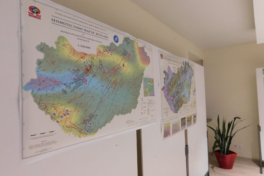
The ELKH Institute of Earth Physics and Space Science (FI) and the GEOMEGA Geological and Environmental Research and Service Ltd. have jointly prepared the seismotectonic risk map of Hungary, which shows young and active fault lines, the distribution and focal mechanism of earthquakes and the most sensitive areas in terms of earthquake risk on a national scale. The seismotectonic map created over four years using a large amount of geophysical data and satellite observations of the Earth can serve as a basis for local seismic risk analysis and strategic infrastructure planning on a national scale, and can also help to ensure earthquake-resistant construction in the future.
Hungary’s earthquake activity is moderate, but this does not mean that all earthquakes are moderate in magnitude, it simply means that large quakes are rare. In the past, the country has been hit by several earthquakes that caused serious damage. Based on the statistical analysis of known quakes, earthquakes with a magnitude greater than 5 on the Richter scale occur on average every 40-50 years in Hungary. Today, the vulnerability of the critical infrastructures of modern society and the economy means that a major earthquake can have unforeseen consequences. Therefore, it is important for researchers to learn as much as possible about the causes of major quakes, how they occur, the process of tectonic movements, and their likely consequences.
The research program led by FI is based on the study of fault lines and crustal movements created by past earthquakes, the structure of the Earth’s crust, with the aim of creating a national model to help analyze the risks of earthquakes, especially when planning large investments. The success of the project has benefited greatly from the large amount of geophysical measurement data that has now been accumulated, as well as the availability of satellite observations of the Earth. These were summarized and analyzed to produce a seismotectonic map showing the young and active fault lines, the distribution and focal mechanism of earthquakes, and the most sensitive areas of Hungary in terms of earthquake hazard. In future, the model can serve as a basis for both local seismic risk analyses and strategic infrastructure planning, thus contributing to the mitigation of the expected consequences of earthquakes, which can provide both a social and an economic benefit.
The project entitled Creating and analyzing the seismotectonic model of Hungary was supported by the Hungarian National Research, Development and Innovation Office with a grant of HUF 206 million from the National Research, Development and Innovation Fund, and was completed within the framework of the National Excellence Program between January 1, 2019 and December 30, 2022.