The researchers of the ELKH Centre for Ecological Research (CER) recently published a study in which they sought to answer the question of how to classify vegetation in areas where (semi)natural vegetation is currently absent or scarcely present. Within the project supported by the Eötvös Loránd Research Network and the Hungarian Ministry of Human Resources, the researchers used statistical methods based on the country's potential vegetation to create a classification of landscape types in Hungary, which they then depicted on a map. This new classification provides a sustainable, natural alternative for the development of urban green infrastructure, contributing to the mitigation of the effects of climate change and promoting the restoration of habitats and habitat complexes. The publication presenting the results was published in the prestigious scientific journal, Preslia.
The classifications and categorizations are also present in our everyday lives and typically aid in understanding. In the case of landscapes, or more precisely, landscape patterns, different landscape classifications serve this purpose. One possible goal is to identify so-called landscape types, i.e., patches that are similar to each other, such as the mosaic of meadows, marshes, and mesic forests, forested landscapes, etc. Although distant areas are often grouped together this way, the value of the classification is that, thinking of a map, patches of the same color indicate similar areas to each other.
A common problem is that based on the actual, i.e., the (semi)natural vegetation that can be observed at present, only such landscape classifications can be made that are dotted with many "white spots" due to human landscape modification activities. In their recently published paper, CER researchers investigated how the landscapes could be classified based on vegetation but without any "white spots."
The concept of potential vegetation offers a solution to this, which refers to the vegetation that can survive in the given area and circumstances. This can be represented as a series of maps, where each map shows the suitability of the environment through a particular vegetation type’s ”eye”. The recently published landscape classification is based on the potential vegetation of Hungary, taking into account the full range of vegetation potential. The classification was conducted using statistical methods, and the resulting classifications can be represented on a map (Figures 1-2), as the coordinates of the rectangular cells are known.
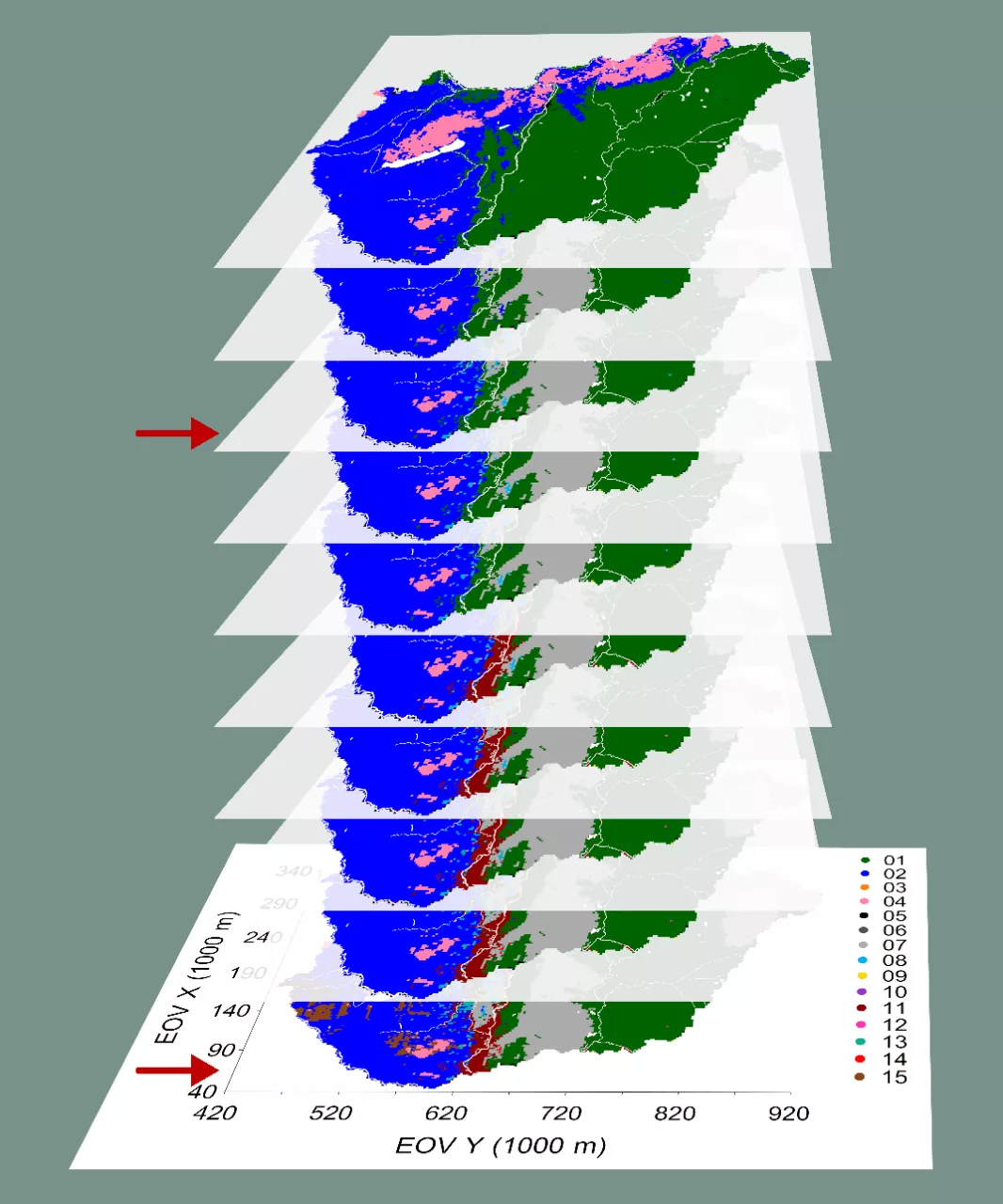
Figure 1: The map representation of the groupings consisting of 6 to 15 groups.
The arrows indicate the maps representing 8 and 15 member groups.
During the examination of the classifications, the 8 and 15 group variants proved to be particularly informative. However, it is important to emphasize that in addition to these two levels of the multi-layered classification, further interesting, differently detailed subdivisions are also available. The purpose of these subdivisions is to provide opportunities for future research so that researchers can select and use the level which is most optimal for them. Stable groups ‒ such as the montane landscape type ‒ and groups that were split subsequently ‒ including the dry and semi-dry forest-grassland mosaic landscape type ‒ were created. An interesting result is that, both the Bereg-Szatmári-sík and Alsó-Duna-völgy regions are suitable for a lowland vegetation in which sandy vegetation types are absent but host a significant proportion of floodplain forests. Thus, they belong to the same group, though they are geographically distant from each other. It is also interesting that the classification shows similarity between the Külső-Somogy, Zselic, and Őrség regions, shown by them being placed into the same group.
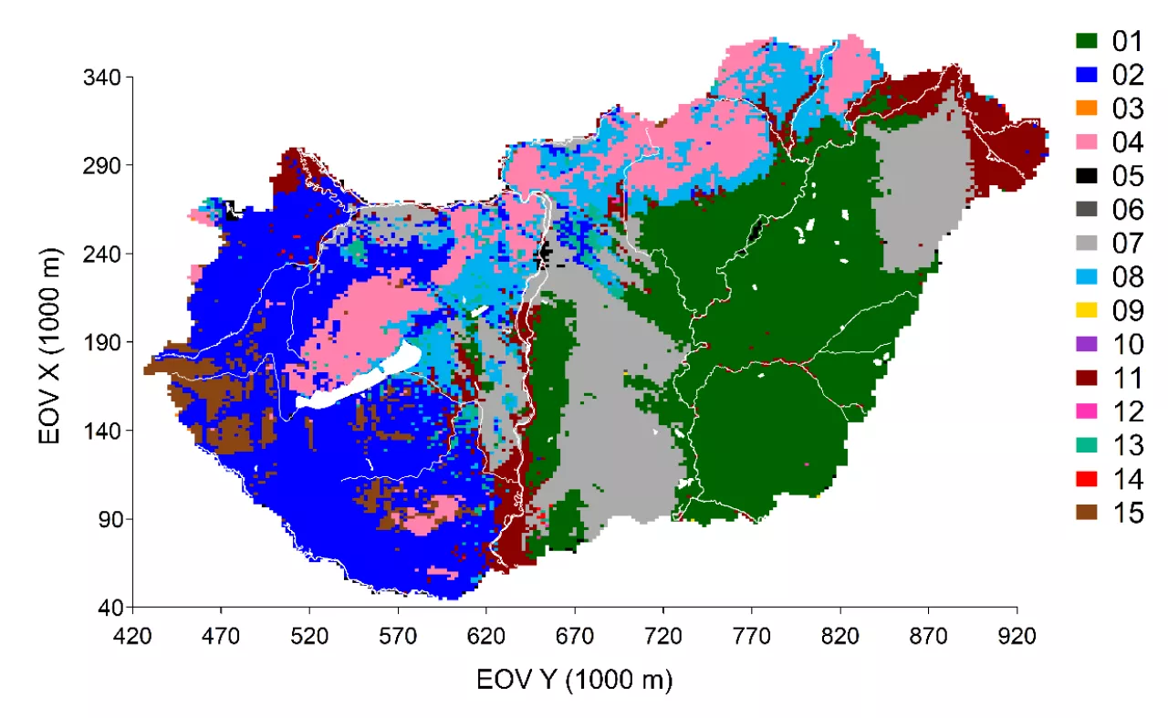
Figure 2: Map representation of the grouping consisting of 15 groups. Landscape types: 01 – Vegetation types of cohesive soils, including halophytic vegetation types, 02 – Mesic colline, deciduous forests, 03 – Not interpreted, 04 – Mountane, 05 – Wet vegetation types, 06 – Not interpreted, 07 – Lowland vegetation types on sand, 08 – Dry, (semi)dry, colline forest, 09 – Not interpreted, 10 – Not interpreted, 11 – Gallery forests, 12 – Not interpreted, 13 – Mosaic of dry, deciduous woodlands and grasslands, 14 – Not interpreted, 15 – Mesic forests, alder woodlands and acidic grasslands as potential replacement vegetation (maintenance of the latter requires active human management, such as mowing or grazing, otherwise it would become shrubby and then wooded).
The researchers compared the new landscape classification based on the potential vegetation to a previous classification that was based on actual (semi)natural vegetation using a similar method. Although the main landscape types can be matched to each other, smaller groups were delimited in the classification based on actual vegetation. An important difference is that the landscape type characterized by floodplain forests is significantly wider along the rivers in the new classification. Another significant difference is that in the previous classification, the first split was based on the presence or absence of trees, while now it is based on topographic conditions. This difference can be explained by the fact that due to human activity, almost all indigenous forests disappeared from the Hungarian lowlands.
The newly created potential vegetation-based landscape classification provides a sustainable, native alternative for the development of urban green infrastructure, contributing to the mitigation of the effects of climate change and promoting the restoration of habitats and habitat complexes. It is a well-known fact in the literature that the probability of successful habitat restoration can be increased by using propagules, such as the seeds of plants adapted to conditions similar to those of the target area to be restored. Furthermore, the landscape classification can also provide assistance in determining the target habitat (complex) to be restored.